Tropical Storm Hilary
Page/Links Last Updated: August 20, 2023
State of Emergency Proclamations:
August 19, Governor Newsom proclaimed a State of Emergency for Fresno, Imperial, Inyo, Kern, Los Angeles, Orange, Riverside, San Bernardino, San Diego, Tulare, and Ventura Counties
August 20, Governor Newsom proclaimed a State of Emergency for Mono County and and issued additional emergency orders for counties included in the August 19 proclamation.
Storm Information

National Hurricane Center Information for Tropical Storm Hilary
National Hurricane Center Active Tropical Cyclones – Eastern Pacific
National Hurricane Center Data in GIS Formats
University Corporation for Atmospheric Research Tropical Storm Hilary Page
Regional and Mesoscale Meteorology Branch Tropical Storm Hilary Satellite Images
GOES-West Satellite Image Viewer – Sector view: U.S. Pacific Coast
Precipitation & Wind
Rainfall
Wind
County Rainfall Maps
Los Angeles County Department of Public Works Rainfall Map (note the Rainfall Data Viewer for this map currently has a scheduled maintenance for 9pm Friday, Sept 9 through 5am Saturday, Sept 10)
Orange County Flood Control District Rainfall Map
Orange County Public Works Rainfall Data Map
San Bernardino WET Rainfall Map
Precipitation Outlook
Day 1
Day 2
Day 3
Excessive Rainfall Potential Maps
Day 1

Day 2

Day 3

In the Excessive Rainfall Outlooks, the Weather Prediction Center (WPC) forecasts the probability that rainfall will exceed flash flood guidance (FFG) within 40 kilometers (25 miles) of a point.
You can access downloadable shape and KML files on the NOAA Weather Prediction Page for Excessive Rainfall
Additional Resource Links
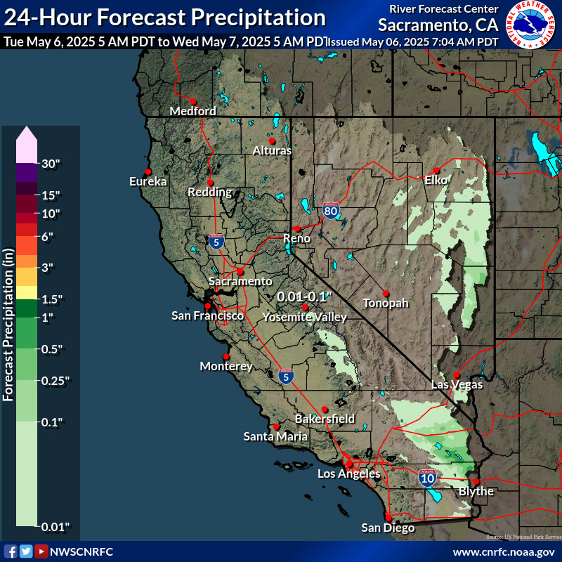
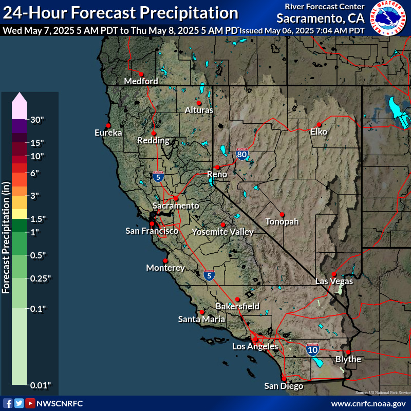
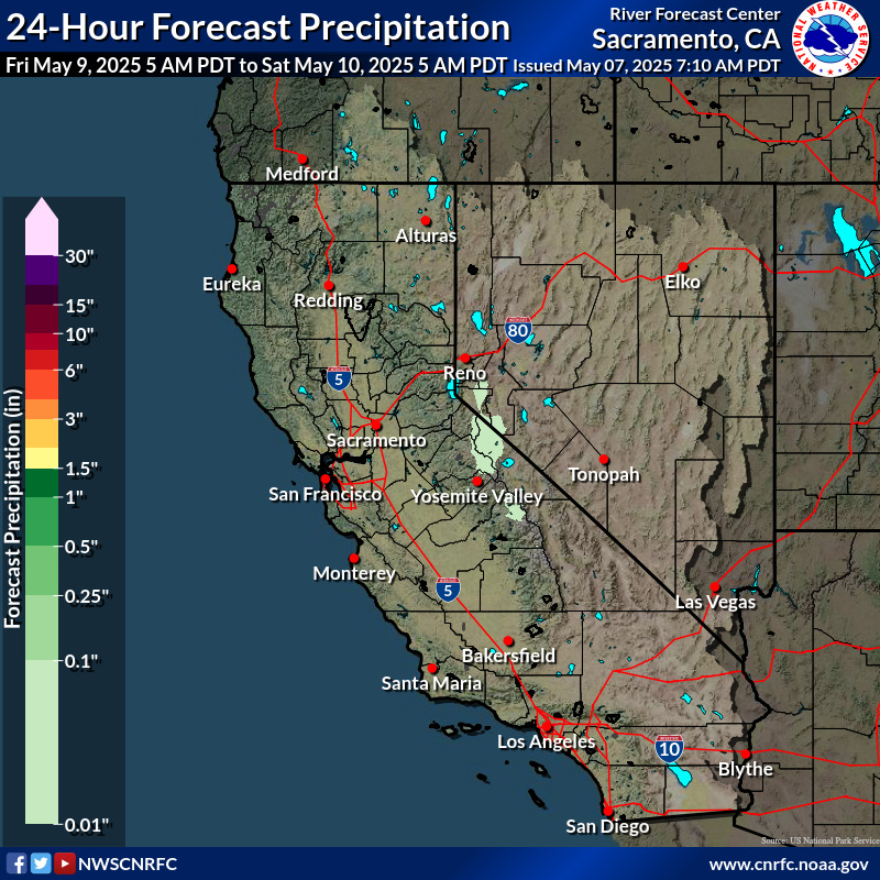
California Nevada River Forecast Center (CNRFC)
CNRFC Maps for Southwest California: Past 1 Hour Past 6 Hours Past 24 Hours
County Links and National Weather Service Watches & Warnings
County Links
Fresno County Emergency Information Page
Fresno County Social Media Pages: Facebook X (Twitter)
National Weather Service Watches, Warnings, & Advisories
 Current watches, warnings, and advisories for Fresno County (CAC019) CA
- An error has occurred, which probably means the feed is down. Try again later.
County Links
Imperial County Fire Department Social Media Page: Facebook
Imperial County Sheriff Social Media Page: Facebook
Imperial County Social Media Page: X (Twitter)
Imperial County Road Conditions
National Weather Service Watches, Warnings, & Advisories
County Links
Ready Inyo County Hurricane Hilary Page
Inyo County Sheriff’s Office Social Media Page: Facebook
Inyo County Social Media Page: Facebook
Inyo County CODERED Emergency Alert Signup
Ventura County Road Closures (will need to click on the link at the bottom for the current list)
National Weather Service Watches, Warnings, & Advisories
Current watches, warnings, and advisories for Inyo County (CAC027) CA
- An error has occurred, which probably means the feed is down. Try again later.
National Weather Service Watches, Warnings, & Advisories
County Links
Los Angeles County Emergency Information Page
Los Angeles County Social Media Pages: Facebook X (Twitter)
Los Angeles County Emergency Notifications Page
Los Angeles County Road Conditions
Los Angeles County Public Works Debris and Mudflow Potential Forecast
National Weather Service Watches, Warnings, & Advisories
Current watches, warnings, and advisories for Los Angeles County (CAC037) CA
- An error has occurred, which probably means the feed is down. Try again later.
National Weather Service Watches, Warnings, & Advisories
Current watches, warnings, and advisories for Orange County (CAC059) CA
- An error has occurred, which probably means the feed is down. Try again later.
County Links
RivCoReady Active Incidents Page
RivCoReady Social Media Pages: Facebook X (Twitter)
National Weather Service Watches, Warnings, & Advisories
County Links
San Bernardino County Storm and Flood Information
San Bernardino County Evacuation Map
San Bernardino County OES Social Media Feeds: Facebook X (Twitter)
San Bernardino County Alert & Warning System
San Bernardino County Nixle Feed
National Weather Service Watches, Warnings, & Advisories
County Links
Alert San Diego Emergency Information Page
San Diego County Emergency Map
AlertSanDiego Emergency Notification Signup
Alert San Diego Social Media Feeds: Facebook X (Twitter)
National Weather Service Watches, Warnings, & Advisories
County Links
ReadySBC Emergency Information Page
County OEM Social Media Feeds: Facebook X (Twitter)
ReadySBC Emergency Notifications
ReadySBC Emergency Notification Signup
Santa Barbara County Nixle Feed
Santa Barbara County Road Closures
Santa Barbara County Flood Control District Rainfall and Reservoir Summary
National Weather Service Watches, Warnings, & Advisories
County Links
Tulare County Emergency Information Page
Tulare County Social Media Pages: Facebook X (Twitter)
Tulare County Fire Dept. Social Media Pages: Facebook
National Weather Service Watches, Warnings, & Advisories
County Links
Ventura County Emergency Operations Center Incident Map
Ventura County Sheriff – Emergency Services Incident Dashboard
Ventura County Sheriff’s Office Social Media Feeds: Facebook X (Twitter)
National Weather Service Watches, Warnings, & Advisories
Current watches, warnings, and advisories for Ventura County (CAC111) CA
- An error has occurred, which probably means the feed is down. Try again later.
Warning – A warning is issued when a hazardous weather or hydrologic event is occurring, is imminent, or has a very high probability of occurring. A warning is used for conditions posing a threat to life or property.
Advisory – Highlights special weather conditions that are less serious than a warning. They are for events that may cause significant inconvenience, and if caution is not exercised, it could lead to situations that may threaten life and/or property.
Watch – A watch is used when the risk of a hazardous weather or hydrologic event has increased significantly, but its occurrence, location, and/or timing is still uncertain. It is intended to provide enough lead time so that those who need to set their plans in motion can do so.
These definitions are from the National Weather Service Glossary.
Waves & Sea Surface Temperatures
Sea Surface Temperatures
GIS Data Resources
Infrastructure/Sector Links
Electric Power
Poweroutage.us California Outage List – This site provides aggregates live power outage data, though may not include some of the smaller local utilities.
US Energy Information Administration’s Southern California Daily Energy Report
Pasadena Department of Water & Power Outage Map
Communications
Cisco’s ThousandEyes Internet Outage Map – covers about 75 business-critical SaaS applications
Fuel
GasBuddy Gasoline Availability Tracker – You will need to zoom in and click “Redo Search in This Area”
US Energy Information Administration’s Energy Infrastructure Hurricanes, Cyclones and Typhoons Map
Roads
CalTrans Check Current Highway Conditions
Caltrans District 1 Updates – covers the counties of Del Norte, Humboldt, Lake, and Mendocino
Caltrans District 2 Updates – covers the counties of Shasta, Siskiyou, Trinity, Tehama, Modoc, Lassen, Plumas, and parts of Butte and Sierra
Caltrans District 3 Updates – covers 11 inland Northern California counties
Caltrans District 4 Updates – covers the Bay Area
Caltrans District 5 Updates – covers Santa Barbara, San Luis Obispo, Monterey, San Benito and Santa Cruz counties
Caltrans District 6 Updates – covers the counties of Fresno, Madera, Kings, and tTulare and western part of Kern county
Caltrans District 7 Updates – covers the counties of Los Angeles and Ventura
Caltrans District 8 Updates – covers the counties of Riverside and San Bernardino
Caltrans District 9 Updates – covers the counties of Inyo and Mono and the easter portion of Kern county
Caltrans District 10 Updates – covers the counties of Alpine, Amador, Calaveras, Mariposa, Merced, San Joaquin, Stanislaus, and Tuolumne
Caltrans District 11 Updates – covers the counties of Imperial and San Diego
CalTrans District 12 Updates – covers Orange county
CalTrans Webcams – If CalTrans Webcam shows “Temporarily Unavailable” – This condition is caused by a problem communicating with the remote camera site to retrieve the picture (JPEG) image.
Aviation
FAA National Airspace System Status
FAA Flight Delay Information – Air Traffic Control System Command Center
FAA No Fly Zones – provides a list of no fly / restricted flight areas
Flight Radar 24 – here you can see flight paths of both planes and helicopters.
