South Fire
Page Last Updated: August 26, 2021
Information per InciWeb
Start Date: August 25, 2021
Initial Location: Lytle Creek
Initial Latitude/Longitude: 34.176, -117.448
Latitude / Longitude Used: initial lat/long 34.176, -117.448
5 Miles Radius Zip Codes: 92336, 92377
5 Miles Radius Towns/Cities: Fontana, Rialto
10 Miles Radius Zip Codes : 92336, 92377, 91739, 92334, 92376, 92335, 91737, 92411, 91759, 92331, 92322, 92405, 92358, 92316, 91701, 92337, 92403, 91730, 92406, 92427, 92423, 92418, 92415, 92413, 92402, 92407, 91729, 92404
10 Miles Radius Towns/Cities: Fontana, Rialto, Rancho Cucamonga, San Bernardino, Mt Baldy, Cedarpines Park, Lytle Creek, Bloomington
20 Miles Radius Zip Codes: 92336, 92377, 91739, 92334, 92376, 92335, 91737, 92411, 91759, 92331, 92322, 92405, 92358, 92316, 91701, 92337, 92403, 91730, 92402, 92406, 92413, 92415, 92418, 92423, 92427, 92407, 91729, 92404, 92325, 92401, 92410, 91764, 91743, 91784, 92509, 92313, 91785, 92408, 92378, 91761, 92369, 92501, 92391, 91786, 92350, 91752, 92397, 92357, 91758, 92354, 92317, 91762, 92324, 92344, 92318, 91711, 92502, 92513, 92514, 92516, 92517, 92519, 92522, 92521, 92507, 92352, 91763, 92346, 92345, 92505, 92321, 92375, 91710, 92374, 91750, 91767, 92557, 92506, 92382, 92860, 92385, 92329, 92371, 92504, 91708, 92503, 92340, 91769, 92880
20 Miles Radius Towns/Cities: Fontana, Rialto,Rancho Cucamonga, San Bernardino, Mt Baldy, Cedarpines Park, Lytle Creek, Bloomington, Crestline, Ontario, Guasti, Upland, Jurupa Valley, Grand Terrace, Rimforest, Patton, Riverside, Twin Peaks, Loma Linda, Mira Loma, Wrightwood, Blue Jay, Colton, Hesperia, Bryn Mawr, Claremont, Lake Arrowhead, Montclair, Highland, Cedar Glen, Redlands, Chino, La Verne, Pomona, Moreno Valley, Running Springs, Norco, Skyforest, Phelan, Corona
30 Miles RadiusZip Codes:92336, 92377, 91739, 92334, 92376, 92335, 91737, 92411, 91759, 92331, 92322, 92405, 92358, 92316, 91701, 92337, 92403, 91730, 92402, 92406, 92413, 92415, 92418, 92423, 92427, 92407, 91729, 92404, 92325, 92401, 92410, 91764, 91743, 91784, 92509, 92313, 91785, 92408, 92378, 91761, 92369, 92501, 92391, 91786, 92350, 91752, 92397, 92357, 91758, 92354, 92317, 91762, 92324, 92344, 92318, 91711, 92502, 92513, 92514, 92516, 92517, 92519, 92522, 92521, 92507, 92352, 91763, 92346, 92345, 92505, 92321, 92375, 91710, 92374, 91750, 91767, 92557, 92506, 92382, 92860, 92385, 92329, 92371, 92504, 91708, 92503, 92340, 91769, 92880, 91766, 92553, 92392, 92373, 92372, 92508, 91768, 91773, 92879, 92341, 92877, 92878, 92359, 92518, 91741, 91709, 91740, 92881, 92554, 91724, 92556, 92551, 92308, 91765, 92395, 92887, 92882, 91789, 91723, 91788, 91791, 92320, 92399, 92393, 92823, 91702, 91722, 93544, 92555, 92886, 91792, 92571, 93563, 92808, 92394, 92570, 92885, 92883, 91793, 92862, 91790, 91010, 91748, 91744, 92807, 91008, 92333, 92572, 92599
Zip Code & Town/City information pulled from FreeMapTools – Find ZIP Codes Inside a Radius
Mile radius size reference points: 5 mile radius covers about 78 sq miles, 10 mile radius covers about 314 sq miles, 20 mile radius covers about 1,257 sq miles, and 30 mile radius covers about 2,827 sq miles.
Acreage size reference points: 1 football field = about 1.3 acres; 640 acres = 1 sq mile;
12,800 acres = 20 sq miles; 32,000 acres = 50 sq miles; 96,000 acres = 150 sq miles; 320,000 acres = 500 sq miles; 480,000 acres = 750 sq mile.
Note about size reference points – fires rarely burn in nice even circles, therefore these reference points are general guides and the shape of the fire perimeter must be taken into account (e.g. a fire burn area may be significantly less than the 1,257 sq miles covered by a 20 mile radius yet extend beyond the 20 mile radius because the burn area is long but narrow).
Resource Links
Fire Information
Southern California Geographic Coordination Center News & Notes
MODIS & VIIRS Satellite Fire Activity Map
red dots = last 12 hours, orange dots = 12-24 hours, yellow dots = last 24-48 hours
NASA FIRMS Satellite Fire Activity Map (downloadable NASA FIRMS – KMZ and Shapefiles)
AlertWildfire Webcams – Some AlertWildfire Webcam rotate and may be pointing away from the fire. You can also navigate to any other AlertWildfire Webcam from the links below.
Fontana 1 Fontana 2 San Timoteo 2
Additional resources via CRA Wildfire Quick Links Page
Additional County Information Links are towards the bottom with the social media feeds
Evacuation & Shelter Information
Support
Demographics
Average Number of Persons per Household:
County: 3.29 State: 2.95
County Percent of Persons:
Under 5 Years: 7.0% Under 18 Years: 26.1% Over 65 Years: 11.9%
Owner-occupied housing unit rate, 2015-2019: 59.8%
Data from US Census Bureau (2019 data)
Note – unless otherwise noted, these are county demographics and local conditions may differ some.
Infrastructure Links
Jump to Section: Resource Links Air Quality Weather Fuel Conditions County Links & Social Media Feeds
Power & Gas
Roads
CalTrans Webcams – If CalTrans Webcam shows “Temporarily Unavailable” – This condition is caused by a problem communicating with the remote camera site to retrieve the picture (JPEG) image.
I-15 : Fontana – 0.25 mi South of Summit I-15 : Fontana – Cherry Undercross I-15 : Fontana – North of Summit I-15 : Rialto – Sierra Avenue I-15 : Fontana – Duncan Canyon I-210 : Rancho Cucamonga – 0.3 Miles West of I-15
Aviation
Mail & Freight Shipping
Air Quality & Smoke Links
US Forest Service BlueSky Daily Runs – Smoke Modeling
US Forest Service BlueSky Daily Runs KMZ and Map Files
AirNow EnviroFlash Map (includes alert notification signup option)
Weather
Wind Map
Temperature Map
National Weather Service Watches, Warnings, and Advisories
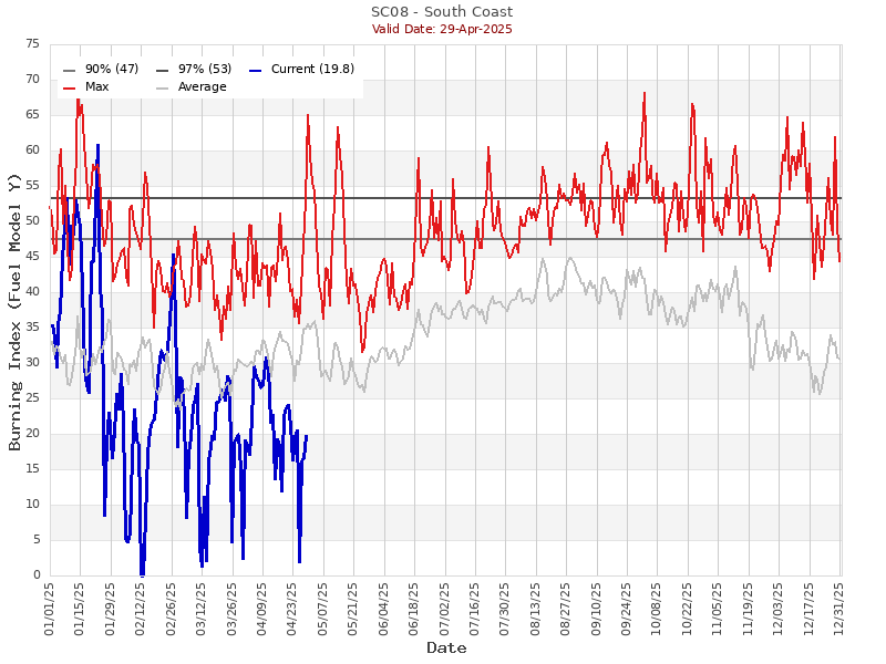
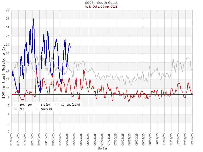
Regional Fuel Conditions
County Links & Social Media Feeds
Jump to Section: Resource Links Infrastructure Links Air Quality Weather Fuel Conditions