Alisal Fire
Page Last Updated: October 15, 2021
Information per InciWeb
Start Date: October 11, 2021
Initial Location: Northwest of Refugio Canyon near Hwy 101 along the Gaviota Coast
Initial Latitude/Longitude: 34.553, -120.136
Latitude / Longitude Used:
10 Miles Radius Zip Codes: 93464, 93463, 93117, 93427
10 Miles Radius Towns/Cities: Solvang, Goleta, Buellton
20 Miles Radius Zip Codes: 93464, 93463, 93117, 93427, 93441, 93460, 93436, 93440, 93107, 93106, 93438, 93116, 93118, 93199
20 Miles Radius Towns/Cities: Solvang, Goleta, Buellton, Los Olivos, Santa Ynez, Lompoc, Los Alamos, Santa Barbara
50 Miles RadiusZip Codes: 93464, 93463, 93117, 93427, 93441, 93460, 93436, 93440, 93107, 93106, 93438, 93116, 93118, 93199, 93111, 93105, 93110, 93455, 93437, 93109, 93190, 93102, 93120, 93121, 93130, 93140, 93150, 93160, 93101, 93454, 93103, 93457, 93429, 93108, 93067, 93254, 93456, 93458, 93013, 93014, 93434, 93444, 93420, 93475, 93421, 93453, 93445, 93001, 93483, 93433, 93022, 93448
Zip Code & Town/City information pulled from FreeMapTools – Find ZIP Codes Inside a Radius
Mile radius size reference points: 10 mile radius covers about 314 sq miles, 20 mile radius covers about 1,257 sq miles, and 50 mile radius covers about 7,854 sq miles.
Acreage size reference points: 1 football field = about 1.3 acres; 640 acres = 1 sq mile;
12,800 acres = 20 sq miles; 32,000 acres = 50 sq miles; 96,000 acres = 150 sq miles; 320,000 acres = 500 sq miles; 480,000 acres = 750 sq mile.
Note about size reference points – fires rarely burn in nice even circles, therefore these reference points are general guides and the shape of the fire perimeter must be taken into account (e.g. a fire burn area may be significantly less than the 1,257 sq miles covered by a 20 mile radius yet extend beyond the 20 mile radius because the burn area is long but narrow).
Resource Links
Fire Information
Southern California Geographic Coordination Center News & Notes
MODIS & VIIRS Satellite Fire Activity Map
red dots = last 12 hours, orange dots = 12-24 hours, yellow dots = last 24-48 hours
NASA FIRMS Satellite Fire Activity Map (downloadable NASA FIRMS – KMZ and Shapefiles)
AlertWildfire Webcams – Some AlertWildfire Webcam rotate and may be pointing away from the fire. You can also navigate to any other AlertWildfire Webcam from the links below.
Additional resources via CRA Wildfire Quick Links Page
Additional County Information Links are towards the bottom with the social media feeds
Evacuation & Shelter Information
Demographics
Average Number of Persons per Household:
Santa Barbara County: 2.91 State: 2.95
Santa Barbara County Percent of Persons:
Under 5 Years: 6.1% Under 18 Years: 22.1% Over 65 Years: 15.7%
Owner-occupied housing unit rate, 2015-2019: 52.1%
Data from US Census Bureau (2019 data)
Note – unless otherwise noted, these are county demographics and local conditions may differ some.
Infrastructure Links
Jump to Section: Resource Links Air Quality Weather Fuel Conditions County Links & Social Media Feeds
Power & Gas
Roads
Aviation
Landfill
Santa Barbra County Public Works Department – Tajiguas Landfill Page
Santa Barbra County public Works Department Twitter Updates
Mail & Freight Shipping
Air Quality & Smoke Links
US Forest Service BlueSky Daily Runs – Smoke Modeling
US Forest Service BlueSky Daily Runs KMZ and Map Files
AirNow EnviroFlash Map (includes alert notification signup option)
Weather
Wind Map
Temperature Map
National Weather Service Watches, Warnings, and Advisories
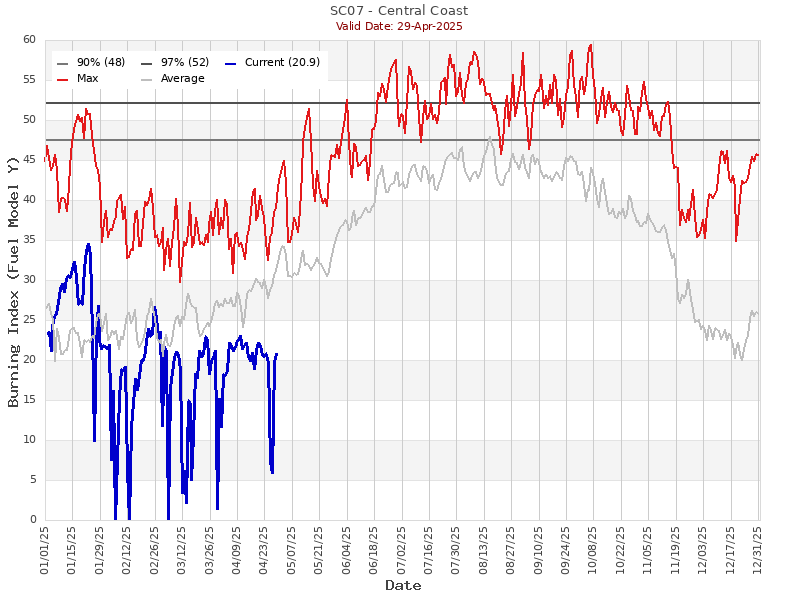
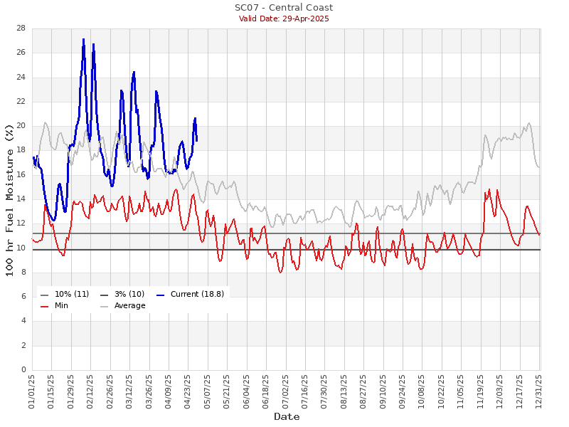
Regional Fuel Conditions
County Links & Social Media Feeds
Jump to Section: Resource Links Infrastructure Links Air Quality Weather Fuel Conditions

