
Sacramento River Flooding
Page Last Updated: January 13, 2023
California Nevada River Forecast Center Links
Links for river forecast points sequenced from the headwaters to the mouth of the river: (Note – these are all the CBRFC forecast points along the river, not all of them may reach monitor or above stage.)
Upper Sacramento River
Sacramento River at Bend Bridge (Tehama County)
Sacramento River at Red Bluff (Tehama County)
Sacramento River at Tehama Bridge (Tehama County)
Sacramento River at Vina Woodson Bridge (Tehama County)
Sacramento River at Hamilton City (Glenn County)
Sacramento River at Ord Ferry (Glenn County)
Sacramento River at Butte City (Glenn County)
Sacramento River at Moulton Weir (Colusa County)
Sacramento River at Colusa Weir (Colusa County)
Sacramento River at Colusa Bridge (Colusa County)
Sacramento River at Tisdale Weir (Sutter County)
Lower Sacramento River
Sacramento River at Fremont Weir (Sutter & Yolo Counties)
Sacramento River at Verona (Sutter County)
Sacramento River at Sacramento at I Street (Sacramento County)
Sacramento River at Rio Vista (Solano County)
Sacramento River Basin Map

USGS Water Alert allows you to get notifications for changes in water conditions based on thresholds you choose. Observation stations are listed from the headwaters to the mouth of the river. Map of USGS observation stations available via the National Water Dashboard. To learn more about the program, visit USGS’s WaterAlerts page.
Sacramento River – Bend Bridge near Red Bluff
Sacramento River – Wilkins Slough near Grimes
Sacramento River – Delta Cross Channel
Current River Levels
Upper Sacramento River

Lower Sacramento River

Source: California Data Exchange Center – Stage Maps, additional maps are available for 1 hour ago and 2 hours ago.
Weather
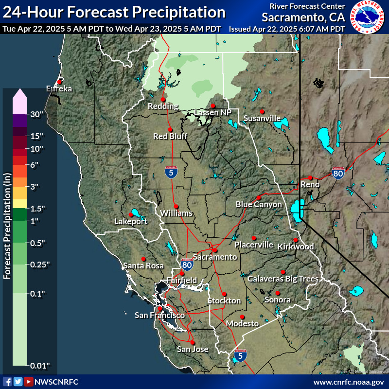
Day 1 Rainfall
Day 2 Rainfall
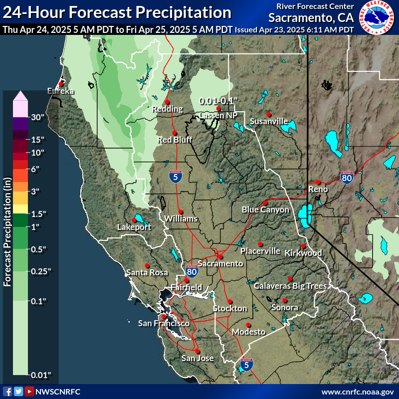
Day 3 Rainfall
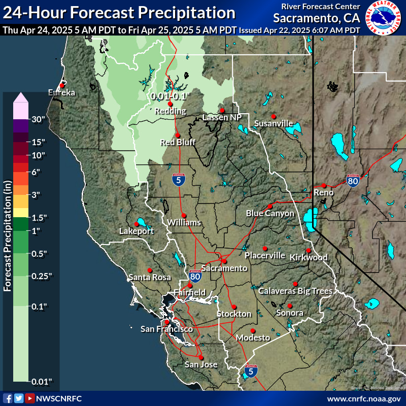
Additional images are available for days 3-6 and for 6 hour intervals for days 1-3 at the California Nevada River Forecast Center page.
National Weather Service Watches, Warnings, & Advisories by County
Warning – A warning is issued when a hazardous weather or hydrologic event is occurring, is imminent, or has a very high probability of occurring. A warning is used for conditions posing a threat to life or property.
Advisory – Highlights special weather conditions that are less serious than a warning. They are for events that may cause significant inconvenience, and if caution is not exercised, it could lead to situations that may threaten life and/or property.
Watch – A watch is used when the risk of a hazardous weather or hydrologic event has increased significantly, but its occurrence, location, and/or timing is still uncertain. It is intended to provide enough lead time so that those who need to set their plans in motion can do so.
These definitions are from the National Weather Service Glossary.
Infrastructure Links
For county specific links see the County Links and Social Media Feeds Section below.
Communications
Xfinity Outage Map (address lookup)
AT&T Outages (address look-up)
Roads
CalTrans Check Current Highway Conditions
Caltrans District 2 Updates – covers the counties of Shasta, Siskiyou, Trinity, Tehama, Modoc, Lassen, Plumas, and parts of Butte and Sierra (feed also viewable in social media section below)
Caltrans District 3 Updates – covers 11 inland Northern California counties (feed also viewable in social media section below)
CalTrans Truck Network Map for District 2
CalTrans Truck Network Map for District 3
Philanthropic Support
Philanthropy California’s 2023 California Disaster Response
Philanthropy California is an alliance of Northern California Grantmakers, Southern California Grantmakers, and Catalyst of San Diego and Imperial Counties. The Philanthropy California team has created a list of vetted to help supporters direct resources to funds supporting non-profits active in place-based relief and recovery efforts with a special focus on supporting communities facing structural impediments.
League of California Community Foundation’s Disaster Relief, Recovery And Resilience Fund
The purpose of this fund is to provide a centralized opportunity for funders to invest in disaster relief, recovery and resilience through community foundations – trusted intermediaries who are deeply connected to affected communities. Community foundations are tax–exempt, nonprofit, autonomous, publicly supported philanthropic institutions that exist to “build community wealth” and serve as hubs of local giving and local impact. They have official public charity status and can engage in both grant making and direct charitable activities.
County Links & Social Media Feeds
Poweroutage.us outage list for Colusa County
Sacramento County Active Storm Information
Sacramento County Rainfall and Stream Level Information System
PowerOutage.us Outage List for Sacramento County
Sacramento County Ready Floods and Rain
Sacramento Alert – Emergency Alerts Notification System
Tehama County Emergency Services Current Disaster Info
Poweroutage.us outage list for Tehama County
Tehama County Flood Control and Water Conservation District Sandbag Information