
Russian River
Page last updated: March 12, 2023
The Russian River hydrologic unit encompasses 1,485 square miles in Mendocino and Sonoma counties, bounded by the Coast Ranges on both the east and west. The mainstem is about 110 miles long, and flows southward from Redwood and Potter valleys (north of Ukiah) to its confluence with Mark West Creek, where it turns west to cut through the coast range and empty into the Pacific Ocean at Jenner. Two reservoirs provide flood protection and water supply storage: 1) Coyote Dam and Lake Mendocino on the East Fork Russian River near Ukiah, and 2) Warm Springs Dam and Lake Sonoma on Dry Creek west of Healdsburg. A diversion from the Eel River through the Potter Valley powerhouse flows through Potter Valley into the East Fork and Lake Mendocino. (Source: California Water Boards)
USGS Water Alert allows you to get notifications for changes in water conditions based on thresholds you choose. Observation stations are listed from the headwaters to the mouth of the river. Map of USGS observation stations available via the National Water Dashboard. To learn more about the program, visit USGS’s WaterAlerts page.
River Monitoring Points
Listed in order from headwaters to the Pacific Ocean
Near Ukiah in Mendocino County
Lat/Long: 39.195447, -123.195005
National Weather Service Advanced Hydrologic Prediction Service
Near Talmage in Mendocino County
Lat/Long: 39.11295, -123.18306, Site Identification Number: 11462080
USGS WaterAlert – Create Alerts for This Location
National Weather Service Advanced Hydrologic Prediction Service
Near Hopland in Mendocino County
Lat/Long: 39.02656314, -123.130558, Site Identification Number: 11462500
California Nevada River Forecast Center – main page and ensemble forecasts
USGS WaterAlert – Create Alerts for This Location
National Weather Service Advanced Hydrologic Prediction Service
Near Cloverdale in Mendocino County
Lat/Long: 38.879348, -123.053612, Site Identification Number: 11463000
USGS WaterAlert – Create Alerts for This Location
National Weather Service Advanced Hydrologic Prediction Service
@ Gyserville in Sonoma County
Lat/Long: 38.712687, -122.89583, Site Identification Number: 11463500
USGS WaterAlert – Create Alerts for This Location
National Weather Service Advanced Hydrologic Prediction Service
@ Jimtown in Sonoma County
Lat/Long: 38.658242, -122.829438, Site Identification Number: 11463682
USGS WaterAlert – Create Alerts for This Location
National Weather Service Advanced Hydrologic Prediction Service
@ Digger Bend near Healdsburg in Sonoma County
Lat/Long: 38.632965, -122.855549, Site Identification Number: 11463980
USGS WaterAlert – Create Alerts for This Location
National Weather Service Advanced Hydrologic Prediction Service
@ Healdsburg in Sonoma County
Lat/Long: 38.613242, -122.836382, Site Identification Number: 11464000
California Nevada River Forecast Center – main page and ensemble forecasts
USGS WaterAlert – Create Alerts for This Location
National Weather Service Advanced Hydrologic Prediction Service
Near Windsor in Sonoma County
Lat/Long: 38.515745, -122.864715
National Weather Service Advanced Hydrologic Prediction Service
At Mirabel in Sonoma County
Lat/Long: 38.499188, -122.896077
National Weather Service Advanced Hydrologic Prediction Service
Hacienda Bridge Near Guerneville in Sonoma County
Lat/Long: 38.508523, -122.927774, Site Identification Number: 11467000
USGS WaterAlert – Create Alerts for This Location
National Weather Service Advanced Hydrologic Prediction Service
@ Guerneville in Sonoma County
Lat/Long: 38.499358, -122.998333
California Nevada River Forecast Center – main page and ensemble forecasts
National Weather Service Advanced Hydrologic Prediction Service
@ Johnsons Beach in Sonoma County
Lat/Long: 38.49935758, -122.9983325, Site Identification Number: 11467002
USGS WaterAlert – Create Alerts for This Location
@ Highway 1 Bridge in Sonoma County
Lat/Long: 38.434022, -123.101108, Site Identification Number: 11467270
USGS WaterAlert – Create Alerts for This Location
National Weather Service Advanced Hydrologic Prediction Service

Current River Levels

Source: California Data Exchange Center – Stage Maps, additional maps are available for 1 hour ago and 2 hours ago.
Other River & Stream Gauge Links
Sonoma County Department of Emergency Management
Stream Gauges Map and Dashboard
Sonoma Water
Upper Russian River Flow Dashboard
Weather
Day 1 Rainfall
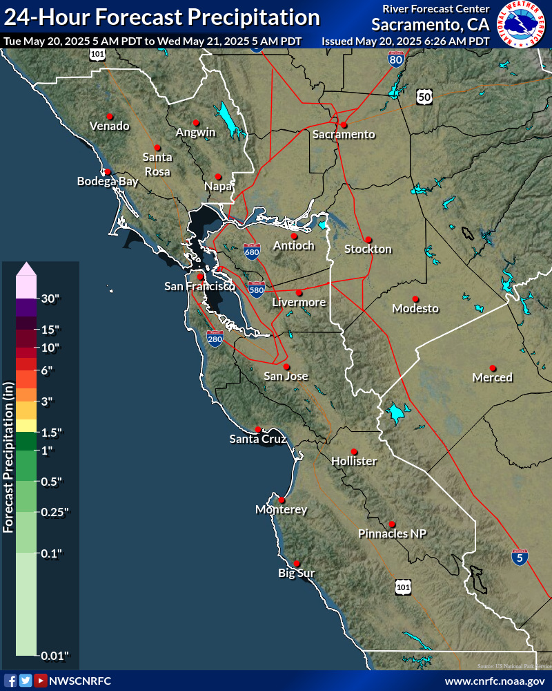
Day 1 Rainfall

Day 1 Rainfall
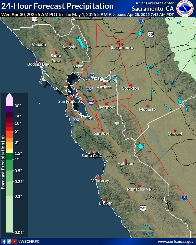
Additional images are available for days 3-6 and for 6 hour intervals for days 1-3 at the California Nevada River Forecast Center page.
National Weather Service Watches, Warnings, & Advisories by County
Warning – A warning is issued when a hazardous weather or hydrologic event is occurring, is imminent, or has a very high probability of occurring. A warning is used for conditions posing a threat to life or property.
Advisory – Highlights special weather conditions that are less serious than a warning. They are for events that may cause significant inconvenience, and if caution is not exercised, it could lead to situations that may threaten life and/or property.
Watch – A watch is used when the risk of a hazardous weather or hydrologic event has increased significantly, but its occurrence, location, and/or timing is still uncertain. It is intended to provide enough lead time so that those who need to set their plans in motion can do so.
These definitions are from the National Weather Service Glossary.
 Current watches, warnings, and advisories for Mendocino County (CAC045) CA
- An error has occurred, which probably means the feed is down. Try again later.
Current watches, warnings, and advisories for Sonoma County (CAC097) CA
- An error has occurred, which probably means the feed is down. Try again later.


